Tag Archives for " general aviation "
GI 275 Adds GFC 500 Autopilot Compatibility
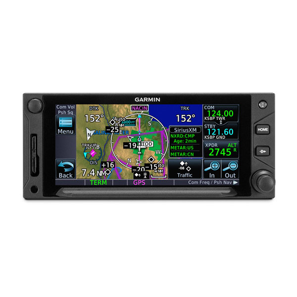
Our GI 275 electronic flight instrument can now be interfaced with the GFC 500 autopilot, delivering superior in-flight performance and added redundancy when multiple GI 275’s are installed in an aircraft. In addition to GFC 500 compatibility, GI 275 can now serve as a replacement attitude indicator and/or horizontal situation indicator (HSI) to legacy Century II/III autopilots. The GI 275 upgrade also includes the display of outside air temperature, groundspeed, true airspeed and wind on the attitude indicator, as well as data field enhancements on the multi-function display (MFD) page.
“The new GI 275 has revolutionized fixed-wing general aviation aircraft instrument panels and today, we’re excited to grow its capabilities and compatibilities even further to include support for our incredibly popular GFC 500 autopilot,” said Carl Wolf, vice president of aviation sales and marketing. “The GI 275 is capable of providing a staggering amount of flight display information in a lightweight and compact design that is easy to incorporate into a variety of cockpits and with its expansive autopilot interface possibilities, it’s a must-have in every cockpit.”
GFC 500 autopilot compatibility with the GI 275
A single GI 2751 electronic flight instrument can now be used as the attitude source to drive the GFC 500 autopilot, while also displaying mode annunciations and flight director indications. Its bright, high-resolution touchscreen display and wide viewing angle offer superior readability in the cockpit. For added redundancy in aircraft equipped with dual GI 275’s, the secondary GI 2751 is capable of coupling to the GFC 500 autopilot, as well. In the unlikely event of a primary GI 275 failure, the autopilot remains fully functional when paired with the secondary GI 275. Additional redundancy is extended to include the G500 TXi & G600 TXi flight displays, which also allow the GI 275 to couple to the GFC 500 autopilot if needed. Unique to the GI 275 and TXi, pilots will receive a mis-compare notification if the AHRS sources between the two do not align.
Century II/III autopilot compatibility
The GI 275’s autopilot interface compatibility continues to grow with the addition of the Century II/III autopilots, which can now be paired with the GI 2752 to replace the antiquated attitude indicator3. When replacing the old attitude indicator, pilots receive a reliable electronic flight instrument with additional capabilities beyond the traditional display of attitude information. Furthermore, unlike legacy attitude indicators paired with the Century II/III autopilots, the GI 275 is capable of disconnecting the autopilot in the unlikely event of an attitude upset or in the event of a mis-compare of attitude data between two GI 275’s.
Additional GI 275 display enhancements
The GI 275 electronic flight instrument is capable of displaying outside air temperature (OAT) and true airspeed (TAS) using a temperature probe. Similar to other Garmin products, OAT is displayed along the bottom of the airspeed indicator on the GI 275, while TAS is displayed on the top of the airspeed indicator. Wind speed and direction is also displayed above the heading and autopilot annunciations on the attitude indicator. Additionally, MFD data field enhancements allow pilots to easily edit and change data fields on the MFD page.
The latest upgrade for the GI 275 is expected to be available in August and pricing for various configurations of the GI 275 can be found on our website. Through July 31, 2020, customers can purchase one GI 275 Engine Indication System (EIS) system for single-engine aircraft or two for a multi-engine aircraft and receive $1,000 USD (per GI 275 system) via a mail-in rebate. Contact a Garmin dealer for additional information. During the week of AirVenture 2020, we will be hosting a series of free educational webinars and product demonstrations, and feature unique opportunities that will bring the Garmin exhibit experience direct to its customers. Check out Garmin’s full line-up of virtual AirVenture Oshkosh events at www.garmin.com/OSH2020. For additional information, visit www.garmin.com/aviation.
1.Requires GI 275 ADAHRS variant.
2.Requires GI 275 ADAHRS + AP variant.
3.Depending on the Century autopilot variant, dual GI 275’s may be required.
The post GI 275 Adds GFC 500 Autopilot Compatibility appeared first on Garmin Blog.
https://www.garmin.com/en-US/blog/aviation/gi-275-adds-gfc-500-autopilot-compatibility/
Garmin Virtual AirVenture Oshkosh Experience
For the first time in over 50 years, Wittman Regional Airport in Oshkosh, WI won’t be playing host to thousands of aircraft and hundreds of thousands of aviation enthusiasts for EAA’s “World’s Greatest Aviation Celebration” — EAA AirVenture Oshkosh. But like EAA and so many of our industry partners, it won’t stop us from connecting with our loyal customers and fans to share the passion for aviation. Beginning Monday, July 20 through Saturday, July 25, our aviation team will host a comprehensive line-up of virtual AirVenture Oshkosh events, including a series of free educational webinars and product demonstrations, and feature unique opportunities that will bring the Garmin exhibit experience direct to our customers. We have also partnered with Mike Patey, FlightChops, Trent Palmer and many more, creating special features to round out the virtual experience. Customers can view a detailed list of events, dates and times by visiting: www.garmin.com/OSH2020.
“EAA AirVenture Oshkosh has long developed into a globally recognized, marquee aviation event over the past five decades (add a couple more decades to include Milwaukee and Rockford!) While we are very disappointed AirVenture Oshkosh will not physically take place as expected this year, we are thrilled to bring eager attendees, loyal customers and friends as much of the Garmin experience to you virtually, and in the best way possible given the times,” said Carl Wolf, vice president of aviation sales and marketing. “Our team has put together a terrific agenda of events for the week, so please join us for as much of it as you can. We look forward to seeing you again in person in 2021!”
Garmin aviation product overview and training webinars
One of the more popular AirVenture experiences at the Garmin exhibit include attending a series of educational Garmin aviation seminars. Ranging from an overview of our latest products, such as the GI 275 and GTN Xi series, to cost-effective autopilot upgrades, these free webinars offer pilots and customers a broad overview of the latest Garmin has to offer.
Training webinars will also be available throughout the week and are led by Garmin’s aviation training department. These webinars will feature a general operational overview of our latest products.
Customers can attend any of the following webinar or training topics throughout the week:
- Latest avionics: GTN Xi series, GI 275 and more
- Latest portables: aera series, inReach and more
- Cost effective autopilot upgrades
- Garmin Pilot: Getting started & Pro Tips
- Cost effective avionics upgrades: G3X Touch for certified aircraft, G5, GPS 175 series
- Solutions for experimental aircraft
- Boldmethod and Garmin present: GTN Xi Vertical Navigation (VNAV)
- Sporty’s and Garmin Present: Preflight weather with Garmin Pilot
- Garmin Pilot: Cross-country planning
- Garmin Pilot: Flying and flight deck connectivity
- GTN Xi IFR approaches, missed and visual approaches, virtual flight
- G3X Pilot academy: Introduction
- G3X Pilot Academy: Autopilot

Aircraft tours and product demonstrations
Just as they would have seen in the Garmin exhibit, customers will have the opportunity to check out aircraft equipped with our latest avionics and view video demonstrations by Garmin experts.
Aircraft tours will include the following Garmin-equipped aircraft:
- Cessna 182
- A36 Bonanza
- RV-7A
Product demonstrations will feature a Garmin expert showing the latest features of Garmin avionics and will include the following products:
- TXi, GTN Xi and GFC 600
- GI 275
- G3X Touch for certified aircraft
- G3X Touch for experimental aircraft
- GFC 500 & GFC 600 autopilots
- G1000 NXi
Exclusive Garmin events
Additionally, we have partnered with some of aviation’s biggest names in the industry to create feature-stories to complement the virtual AirVenture experience. Some of those include Mike Patey, who will unveil the completed panel of his G3X Touch-equipped “Scrappy” aircraft. Mike Patey will also be available for an exclusive Live Q&A session.

Schedule a one-on-one discussion with a Garmin expert
Similar to meeting with a Garmin expert one-on-one at the exhibit, customers can schedule individual discussions with a Garmin expert throughout the week of our virtual AirVenture. These sessions will be held online via Microsoft Teams and allow customers to ask operational questions or receive support updating databases or software. During these individual meetings, customers can also receive an individualized consultation on upgrating the avionics in their aircraft, ask troubleshooting questions regarding their experimental avionics installations, and receive help with Garmin Pilot. To schedule a one-on-one meeting with a Garmin expert, visit www.garmin.com/OSH2020.
To view the full schedule and register for specific events, visit: www.garmin.com/OSH2020 For additional information, visit: www.garmin.com/aviation.
The post Garmin Virtual AirVenture Oshkosh Experience appeared first on Garmin Blog.
https://www.garmin.com/en-US/blog/aviation/garmin-virtual-airventure-oshkosh-experience/
Kansas City Group Educating Next Generation Aviators, Technicians
Believe it or not, the future of aviation is in America’s heartland — Ottawa, Kansas, to be exact. Ottawa is located on the outskirts of Kansas City, on the Kansas side of the border, some 30 miles southwest of the Garmin International headquarters. There a determined group of students are on a mission to give an aviation icon a 21st century makeover. The icon: a 1967 Piper Cherokee. The students — not yet enrolled in an aeronautical university — but rather a collection of ambitious middle school and high school students under the guidance of aviation industry professionals and mentors. The goal is not just to return the airplane to the sky but also to gain valuable aviation knowledge and technical skills.
The Aviation Explorers, the industry’s next generation
Founded in 2015, the Aviation Explorers Post 8000 was established as a nonprofit organization within the Boy Scouts of America. Its mission is to provide aviation learning and career-exploring opportunities for middle and high school students, as well as leadership and hands-on experiences that could translate to real-world career opportunities. Learning how to fly was a pillar for the group, and they were determined to find a way to reduce barriers and create more opportunities for aspiring young students to achieve this goal.

Vintage airplane, new avionics
Milton Scott — a lead aircraft maintenance technician in Garmin’s flight operations department — has been instrumental in helping establish the organization along with teaching and mentoring the students on the technical aspects of aviation. After helping to get the organization get off the ground, the Aviation Explorers received the generous donation of a 1967 Piper Cherokee. The goal was simple: return the aging airplane to airworthy status and learn about aircraft maintenance along the way. Having a flyable airplane in the organization would create a number of new opportunities, especially for those interested in learning to fly.
The original equipment in a ’60s-era airplane can leave a lot to be desired. So Garmin’s aviation team decided to help. They supplied a number of new cost-effective solutions tailored for training aircraft like Piper Cherokees, including a GNX 375 GPS navigator and ADS-B transponder, two GNC® 255 Nav/Comm radios and a GMA 345 audio panel with BLUETOOTH® connectivity.
“The students worked on everything,” said Scott. “From setting up the radio racks, making the wiring harnesses, tying the wire harnesses, and installing the circuit breakers and headset/microphone sockets. They even tested all the wiring before applying power.”

After updating the avionics, the students helped complete the remaining maintenance tasks required to return the aircraft to service.
“Right now, the airplane is available for any of our students to use for flight lessons,” Scott added. “They just have to pay for gas.”
That was their idea from the beginning. And they have succeeded — several students have earned or are close to earning their pilot’s license in the organization’s Piper Cherokee.
What’s next?
Although the airplane returned to flight and its mission of teaching student pilots, there is always room for improvement.
“We’re already planning to install two Garmin G5 electronic flight instruments, a GAD 29 (compact GPS/navigation data interface adapter) and GMU 11 (magnetometer) later this year,” Scott said.
For more information about our latest cost-effective avionics solutions, visit Garmin.com/aviation.
The Bluetooth word mark and logos are registered trademarks owned by Bluetooth SIG, Inc. and any use of such marks by Garmin is under license.
The post Kansas City Group Educating Next Generation Aviators, Technicians appeared first on Garmin Blog.
https://www.garmin.com/en-US/blog/aviation/kansas-city-group-educating-next-generation-aviators-technicians/
New Aircraft Models Approved for GFC 500 and GFC 600 Autopilots
Our GFC 500 and GFC 600 digital autopilots have received FAA Supplemental Type Certification in several aircraft models. The GFC 500 and GFC 600 deliver superior in-flight characteristics, self-monitoring capabilities and minimal maintenance needs when compared to older generation autopilot systems. The GFC 500 is intended for piston aircraft, while the GFC 600 is intended for high performance piston and turbine aircraft that have a wide range of speed and performance characteristics.
New aircraft models approved for the GFC 500 autopilot include:
- Aviat Husky
- Models: A-1, A-1A, A-1B, A-1C-180, A-1C-200
- Cessna 206
- Models: U206F (s/n U20602200 and later), TU206F (s/n U20602200 and later), U206G, TU206G, 206H, T206H
New aircraft models approved for the GFC 600 autopilot include:
- Cessna 425
- Models: 425
The GFC 500 autopilot uniquely integrates with the G5 electronic flight instrument or a combination of both the G5 electronic flight instrument and G3X Touch, G500 TXi or G500 flight displays to provide pilots with an economical and modern autopilot solution. The GFC 600 is designed as a standalone autopilot and also boasts superior integration potential when paired with the G500 TXi/G600 TXi or G500/G600 glass flight displays, Garmin navigators, as well as a variety of third-party flight displays, instruments and navigation sources.

The full-featured GFC 600 and GFC 500 autopilots provide thousands of existing general aviation aircraft with a simple, light-weight, cost-effective autopilot upgrade path. The GFC 600 and GFC 500 incorporate solid state attitude with robust self-monitoring capabilities to provide superior autopilot performance, greater reliability and safety benefits that are similar to the popular GFC 700 autopilot. In addition to traditional autopilot capabilities such as altitude hold, vertical speed and heading modes, the GFC 600 and GFC 500 also include altitude preselect, VNAV1, Level Mode, underspeed and overspeed protection and more. Pilots can also select, couple and fly various instrument approaches, including GPS, ILS, VOR, LOC and back course approaches when paired with a compatible GPS navigator.
As a standard feature on both the GFC 500 and GFC 600 autopilots, pilots receive Garmin Electronic Stability and Protection (ESP), which works to assist the pilot in maintaining the aircraft in a stable flight condition. ESP functions independently of the autopilot and works in the background to help pilots avoid inadvertent flight attitudes or bank angles and provides airspeed protection while the pilot is hand-flying the aircraft.
For customers who already have a G5 electronic flight instrument, the GFC 500 starts at a suggested retail price of $6,9952 for a 2-axis autopilot. The GFC 600 autopilot starts at a suggested retail price of $19,9952 for a 2-axis autopilot with electric pitch trim. Pricing is for retrofit installations only. The GFC 500 autopilot will also be available as an option on new Aviat Husky aircraft.
Garmin continues to add additional aircraft models to the growing STC list for the GFC 500 and GFC 600 autopilots. To view the most up-to-date aircraft STC list, to view certification programs that are expected to begin in the next 12-months, or to express interest in a specific aircraft make/model, visit: www.garmin.com/GFC500 or www.garmin.com/GFC600.
1. GTN navigator required
2. Installation not included
The post New Aircraft Models Approved for GFC 500 and GFC 600 Autopilots appeared first on Garmin Blog.
https://www.garmin.com/en-US/blog/aviation/new-aircraft-models-approved-for-gfc-500-and-gfc-600-autopilots/
Garmin Autoland Achieves FAA Certification for General Aviation Aircraft
Garmin Autoland is now FAA certified and available on the G3000 integrated flight deck in the Piper M600. In the event of an emergency, Autoland will control and land the aircraft without human intervention. The award-winning system is also featured on the Cirrus Vision Jet and Daher TBM 940 and will soon be available on these aircraft, with additional aircraft approvals to follow.
“What started as a vision to develop the world’s first Autoland system for general aviation, became a reality today as we deliver one of the industry’s most significant innovations,” said Phil Straub, Garmin executive vice president and managing director of aviation. “Congratulations to the entire Garmin team who contributed to the development and certification of Autoland – one of the industry’s most forward- thinking technologies that will forever enhance aviation safety and save lives.”
In the event of an emergency, the pilot or passengers on board the aircraft can activate Autoland to land the aircraft with a simple press of a dedicated button. Autoland can also activate automatically if the system determines it’s necessary. Once activated, the system calculates a flight plan to the most suitable airport, while avoiding terrain and adverse weather, initiates an approach to the runway and automatically lands the aircraft – without pilot or passenger intervention.

Autoland takes into account a breadth of information and criteria during an activation, including a wide range of performance, operational and environmental factors. The availability of a GPS approach with lateral and vertical guidance to the runway is also required when the system is considering various airports and runways. Even further, the system will automatically communicate with air traffic control, advising controllers and pilots operating near the aircraft of its location and its intentions.
Throughout an Autoland activation, the G3000 integrated flight deck provides passenger-centric visual and verbal communications in plain-language so passengers in the aircraft know what to expect. The flight displays show the aircraft’s location on a map alongside information such as the destination airport, estimated time of arrival, distance to the destination airport and fuel remaining. Airspeed, altitude and aircraft heading are also labeled in an easy-to-understand format. Passengers also have the option to communicate with air traffic control by following simple instructions on the display using the touchscreen interface on the flight deck.
The Garmin Autothrottle system is used to automatically manage aircraft speed, engine performance and engine power so the aircraft can climb, descend or maintain altitude as needed during an Autoland activation. On approach to land, the system initiates a controlled descent to the airport. If the aircraft needs additional time to descend or slow down during the approach, the Autoland system initiates a standard holding procedure. When aligned with the runway, the landing gear and flaps are automatically extended and the aircraft continues its descent. On the runway, automatic braking is applied while tracking the runway centerline to bring the aircraft to a full stop. Engine shutdown is also automated so occupants can safely exit the aircraft.
At any time, a pilot can easily deactivate an Autoland activation. With a single press of the “AP” autopilot key on the autopilot controller or the autopilot disconnect button on the controls, an Autoland activation can be canceled. The flight display shows a message that confirms Autoland has been deactivated and in the event of an accidental deactivation, the system shows passengers how to reactivate Autoland if needed.
Garmin Autonomí, a family of autonomous safety solutions, encompasses Autoland, Emergency Descent Mode (EDM) and Electronic Stability and Protection (ESP). These technologies add to the safety enhancing tools and capabilities of a Garmin-equipped flight deck. For example, in the event an aircraft loses pressurization, EDM is capable of automatically descending the aircraft to a preset altitude without pilot intervention to help avert hypoxic situations.
ESP further enhances the Autonomí suite by working to assist the pilot in avoiding unintentional flight attitudes beyond that for normal flight. ESP works in the background while the pilot is hand flying the aircraft to help pilots avoid inadvertent flight attitudes or bank angles. Should the pilot become inattentive while hand flying the aircraft and exceed pre-determined pitch, roll or airspeed limitations, Garmin ESP activates and the pilot will feel pressure on the flight controls that guide him/her back to a recommended flight limit.
For additional information regarding the Garmin Autonomí family of autonomously activated flight technologies, visit www.garmin.com/Autonomi.
The post Garmin Autoland Achieves FAA Certification for General Aviation Aircraft appeared first on Garmin Blog.
https://www.garmin.com/en-US/blog/aviation/garmin-autoland-achieves-faa-certification-for-general-aviation-aircraft/
aera 760: 7-inch Format Portable Aviation GPS
Garmin TeamX unveiled the aera 760, a premium aviation portable that is purpose-built for the pilot and the cockpit. The aera 760 boasts a 7-inch bright, sunlight readable touchscreen display complete with comprehensive chart options in a compact and dedicated portable GPS. Additional features of the aera 760 include the option to load instrument approach procedures, arrivals and departures, approach chart overlay on the map, Garmin Connext wireless connectivity, as well as the option to integrate it with select Garmin avionics. The aera 760 is expected to be available in May for a list price of $1,599 USD.
“On behalf of our innovative and nimble TeamX gang of aviation enthusiasts, we’re excited to introduce the latest edition to the distinguished family of Garmin portable GPS products, the feature-packed aera 760,” said Carl Wolf, vice president of aviation sales and marketing. “For nearly three decades, Garmin has sold hundreds of thousands of portable GPS products for aircraft big and small. Building upon our acclaimed portable aviation GPS line-up, the aera 760 has the most robust aviation feature set to-date, that is designed exclusively by pilots – for pilots.”
Featuring a modern yet rugged design, the aera 760 is an all-in-one aviation portable complete with a built-in GPS/GLONASS receiver that is optimized for the cockpit. Its bright, 7-inch sunlight readable display can run on battery power for up to four hours on a single charge. Along the bezel, an industry-standard USB-C connection is used to charge and power the aera 760, while a microSD card slot allows pilots to load topography and street maps or use it to easily transfer user waypoints. The aera 760 features an intuitive user-interface resembling that of many other popular Garmin products such as the GTN Xi series, G3X Touch and Garmin Pilot allowing pilots to easily transition between multiple Garmin products in the cockpit. Capable of operating in harsh conditions, the aera 760 has also been tested and hardened to meet stringent temperature and vibration standards.
New to the aera 760, pilots can load departures, arrivals and instrument approach procedures (IAPs) within a flight plan, which can be wirelessly transferred to a navigator in the cockpit. Once a procedure is loaded within the aera 760, pilots have the option to view the chart or they can overlay it on the moving map. IFR enroute charts, VFR sectionals and Garmin FliteCharts are also geo-referenced, providing optimal situational awareness. Jeppesen electronic charts are compatible with the aera 760 and give customers worldwide access to instrument approach chart information. In addition to procedures, victor airways, user-defined holds and holds over an existing navigation fix can be entered into a flight plan.
Built-in Wi-Fi and Bluetooth allow the aera 760 to take advantage of Garmin Connext wireless connectivity inside and outside of the cockpit. When connected to Wi-Fi, pilots can easily download aviation database and software updates without the need to physically connect it to a computer. Prior to departure, pilots can also view worldwide weather information on the aera 760 when it’s connected to Wi-Fi. In the cockpit, it is capable of wirelessly connecting to select products such as the GTX 345 or the GDL 52 to display the benefits of Automatic Dependent Surveillance-Broadcast (ADS-B) traffic, Flight Information Service-Broadcast (FIS-B) weather, SiriusXM aviation weather and more via Bluetooth. Exclusive features such as TerminalTraffic and TargetTrend can also be viewed on the moving map and dedicated traffic pages.
Pilots can hard-wire the aera 760’s power, audio and dual RS-232 connections to receive additional benefits. When connected to a navigator such as the GTN 650Xi/750Xi, GTN 650/750 or the GNS 430W/530W, the aera 760 can send and receive flight plan data that is entered into the navigator over a serial port so all products remain synchronized throughout the flight. It is also capable of wirelessly connecting to these navigators when paired with a Flight Stream 210/510. When connected to a NAV/COM such as the GTR 225, GNC 255 or GTR 200, frequencies and airport identifiers can also be transferred from the aera 760 to the corresponding NAV/COM. For aircraft flying in visual conditions, pilots can optionally connect the aera 760 to select autopilots to fly lateral GPS and single point vertical navigation (VNAV) guidance. For example, pilots flying in visual conditions can fly a VNAV profile from their current altitude to pattern altitude using the aera 760 fully coupled to the autopilot.

3D Vision technology displays a virtual 3D perspective view of surrounding terrain, obstacles and airports, as well as a horizontal situation indicator (HSI) that is capable of showing lateral and vertical deviation bars. When the aera 760 is panel mounted or paired with a compatible attitude source such as a GDL 52 or GTX 345, pilots can view synthetic vision (SVX), which adds the display of back-up attitude information on the portable.
The aera 760 also features fuel price information, an E6B flight computer and weight and balance calculators. The E6B can be used prior to a flight to aid in calculating fuel burn, estimated time of arrival (ETA) and more. While in-flight, the aera 760 utilizes ground speed information to recalculate fuel burn and ETA. Helicopter operators also have access to features tailored to their unique operations, such as WireAware wire-strike avoidance technology. WireAware overlays power line locations and relative altitude information on the moving map and provides both aural and visual alerting when operating near power lines. Pilots also have the option to enter street intersections or non-aviation waypoints. GPS altitude display is offered in both mean sea level (MSL) and above ground level (AGL), so they are easier to identify relative to the aircraft flight path.
The aera 760 is expected to be available in May for a list price of $1,599 USD and is compatible with the cost-effective Garmin Navigation Database that is available in the Americas with US coverage starting at $39.95 for a single update. A variety of annual bundles are also available on the flyGarmin website, such as the U.S bundle for $169.95, which includes the Garmin Navigation Database, FliteCharts, IFR/VFR Charts, terrain, obstacles, SafeTaxi, and the airport directory with fuel prices. Pilots can also add enhanced map information such as topography or street maps using a MicroSD card. The aera 760 is supported by our award-winning aviation support team, which provides 24/7 worldwide technical and warranty support. For additional information, visit www.garmin.com/aera760.
The post aera 760: 7-inch Format Portable Aviation GPS appeared first on Garmin Blog.
https://www.garmin.com/en-US/blog/aviation/aera-760-7-inch-format-portable-aviation-gps/
Garmin Partners with University of Kansas on Environmental Research Plane
In Lawrence, Kansas, a team at the University of Kansas School of Aerospace Engineering has taken technology from the 1970s and created a tool designed to gather environmental research data. The technology? A 1974 Cessna 172. The team has specially modified the aircraft with an advanced airborne radar designed to measure regional snow thickness throughout South Dakota’s Black Hills region.
The Mission
After spending four years in the hangar, the KU team restored a Cessna 172 to operational status to be used as a vehicle for gathering research data. A specially designed snow radars was installed on the classic Cessna and put into service gathering data throughout the Black Hills. The radars measure snow levels as the aircraft flies grid-like patterns over a specific area.
“The measurements will be used for hydrological models to help predict stream flow,” said Emily Arnold, assistant professor, University of Kansas Aerospace Engineering Department. “If they know how much snow there is, they can help determine how much water is going to run off into a stream and help determine how much water will be available to people within a region as they manage the resource.”
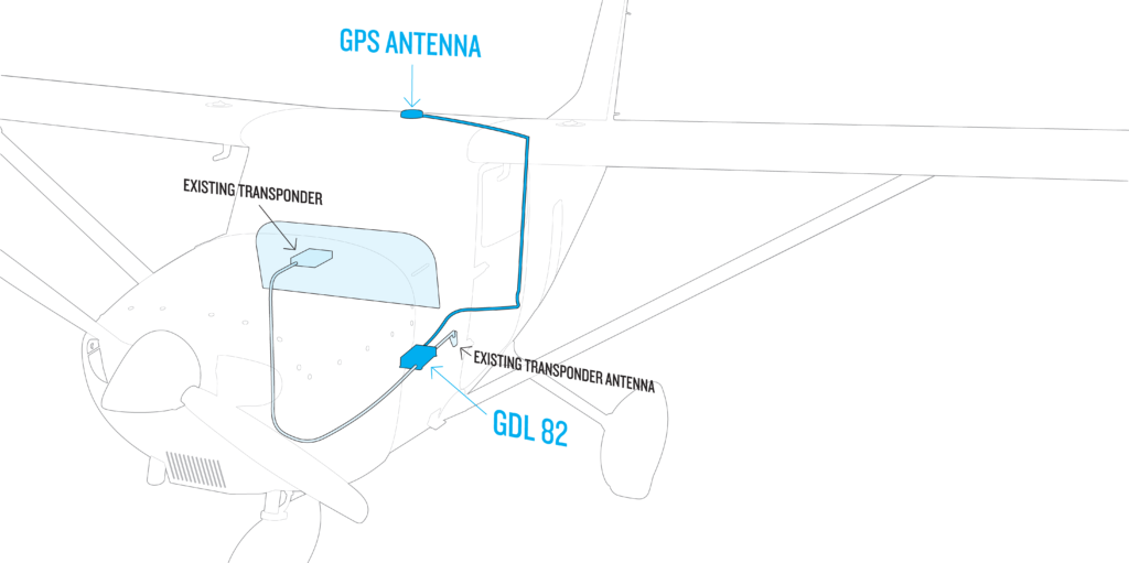
We helped the team meet 2020 FAA ADS-B requirements by providing our GDL 82 ADS-B “Out” datalink. This small, lightweight, easy-to-install 978 MHz universal access transceiver features our patented AutoSquawk technology. It’s a cost-effective solution for aircraft that operate in controlled U.S. airspace below 18,000 feet and was an ideal solution for the KU engineering team because they wanted to keep the aircraft’s existing transponder.
What’s next for the Cessna 172?
“Sense and avoid research with UAVs (unmanned aerial
vehicles),” said Arnold. “The Cessna 172 is a valuable resource within our
department. Having an aircraft like that makes performing our research more
cost-effective.”

To learn more about our GDL 82 ADS-B “Out” datalink, visit Garmin.com/GDL82.
The post Garmin Partners with University of Kansas on Environmental Research Plane appeared first on Garmin Blog.
https://www.garmin.com/en-US/blog/aviation/garmin-partners-with-university-of-kansas-on-environmental-research-plane/
Flight Deck Technology, Tools Added to Garmin Pilot App
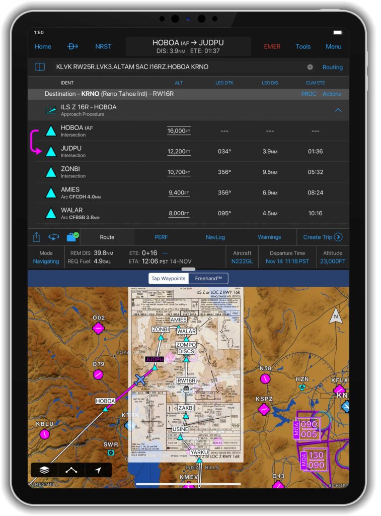
Advanced new features and professional IFR navigation tools are now available within our Garmin Pilot app, many of which incorporate a familiar look and feel to our most popular flight decks and avionics. Pilots can experience a near-seamless transition between Garmin avionics and Garmin Pilot when performing common functions, such as loading and activating instrument approach procedures, departures and arrivals within the Americas. Additional features such as a visual procedure selector, custom holding patterns and more, give pilots convenient access to advanced tools all within a mobile app.
“Leveraging technologies found within Garmin avionics and flight decks,
we’re excited to bring this game-changing update to Garmin Pilot customers,” said
Carl Wolf, vice president of aviation sales and marketing. “This latest upgrade
gives pilots the ability to load complex routes and procedures into the app
just as they would within a Garmin integrated flight deck, offering added
convenience, time savings and confidence when transitioning between multiple
Garmin products in the cockpit.”
Professional IFR
navigation tools
Within the
latest Garmin Pilot upgrade, pilots have the option to load or activate departures,
arrivals and instrument approach procedures. Published holds that are included
as part of the missed approach are also added to the flight plan. When pilots
activate a procedure with published altitude constraints, those altitudes are automatically
incorporated into a flight plan within the app. Pilots can also choose to manually add altitude constraints to a flight
plan. Additionally, approach procedures with radius-to-fix (RF) legs can be
activated within Garmin Pilot.
Using the
vertical planning feature within Garmin Pilot, pilots can more easily input and
adhere to crossing restrictions in a flight plan. For example, pilots can
manually input a crossing restriction over a specific navigational aid or GPS
waypoint. With these new features, pilots can optimize their flight planning
and fuel calculations.
Visual procedure selector
Pilots can
now more easily visualize departures, arrivals and instrument approach
procedures prior to a flight using the visual procedure selector. This new
selector allows pilots to simultaneously view departures, approaches or arrivals
on a map alongside a flight plan so it’s easier to visualize and select the
most appropriate procedure based on a flight plan and intended direction of
flight.
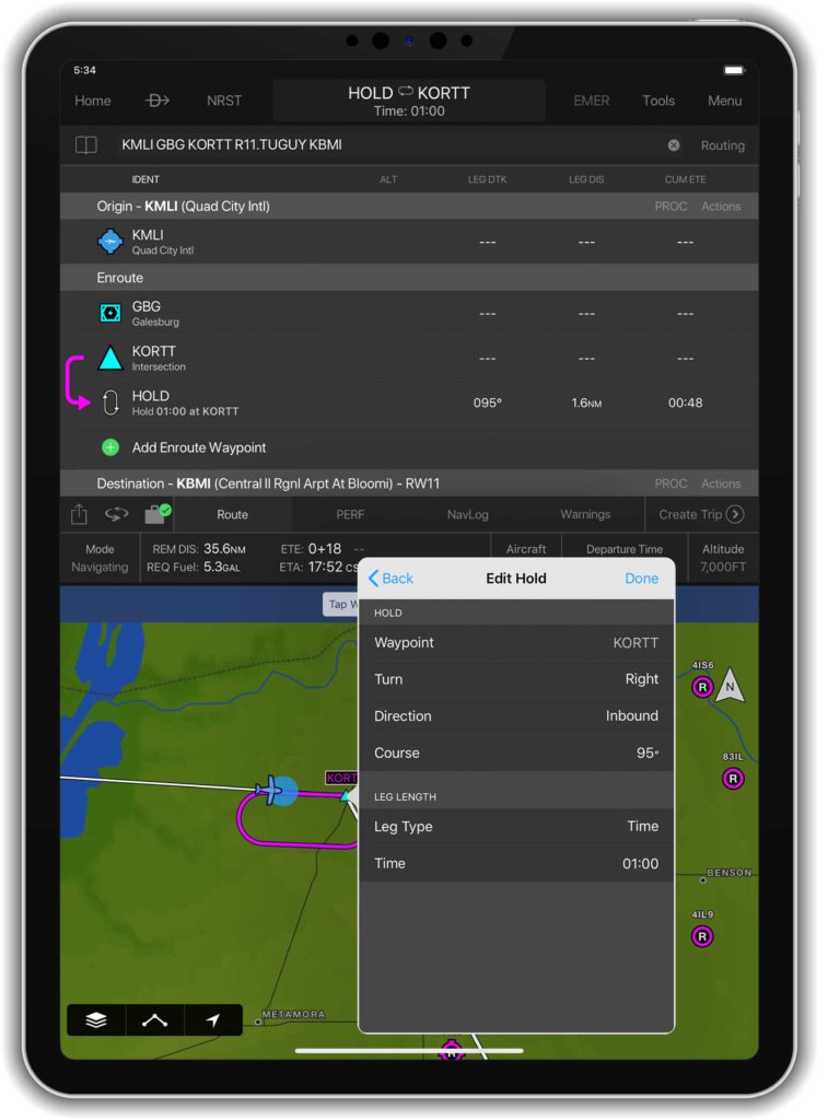
Customized
holding procedures
Pilots now have the flexibility to easily
build customized holding patterns. These holds may be created over an existing
fix or over a user-defined waypoint and then inserted into a flight plan. When
creating a hold, pilots can easily input an inbound or outbound course, select
left or right turns and specify leg length in time or distance. Unpublished
holds or those assigned by air traffic control are easily created and displayed
within Garmin Pilot to simplify the process of visualizing and flying a holding
pattern.
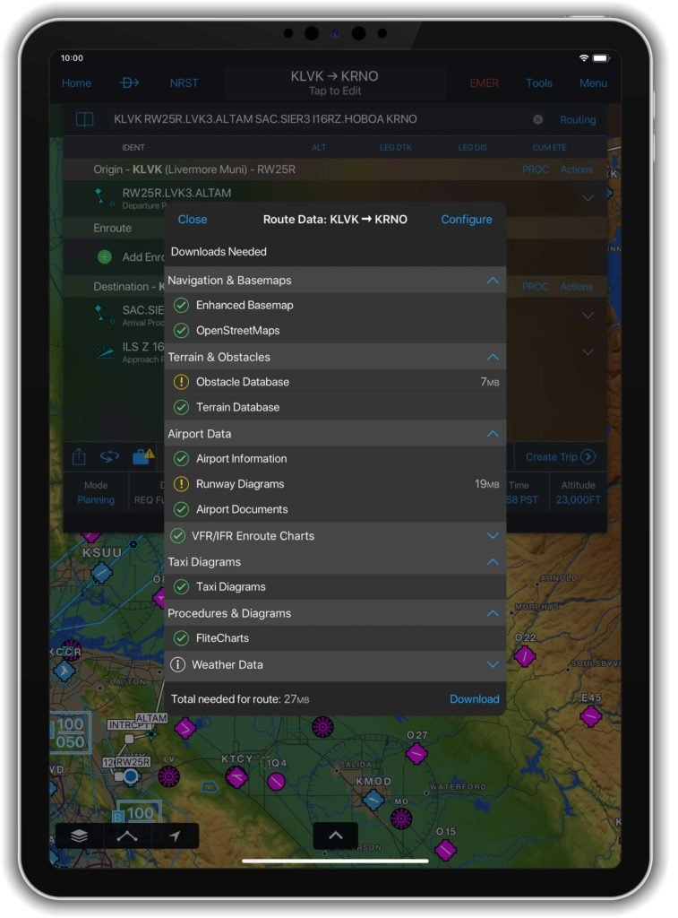
Worldwide
route data packages
Route data packages within Garmin Pilot help to ensure pilots have downloaded all of the data required for a flight plan. Once a flight plan is entered, pilots can review the data that is downloaded to their mobile device. If information is missing for a particular flight, Garmin Pilot displays an option to download additional data. Route data packages are also available worldwide to help ensure pilots have all of the data they need prior to every flight. Databases that are included within the worldwide route data packages include navigation data, instrument approach procedures, SafeTaxi, terrain, obstacles and more.
The newest release of Garmin Pilot on Apple mobile devices is available immediately. For new customers, Garmin Pilot is available in the Apple App Store as a free download for the first 30 days. After the 30-day trial period, customers may purchase an annual subscription of Garmin Pilot starting at $79.99.
The post Flight Deck Technology, Tools Added to Garmin Pilot App appeared first on Garmin Blog.
https://www.garmin.com/en-US/blog/aviation/flight-deck-technology-tools-added-to-garmin-pilot-app/
GTN Xi Series: Fourth Generation GPS/NAV/COMM Solutions
The next generation of in-flight navigation technology has arrived. Our GTN 650Xi and GTN 750Xi—the fourth generation of GPS/NAV/COMM solutions—are designed as a direct slide-in upgrade to the previous generation GTN 650/750, allowing pilots to preserve their panel and modernize the cockpit at the same time. The all-in-one GPS/NAV/COMM boasts a feature-rich multifunction display and can integrate with new or existing remote-mount equipment such as a transponder or audio panel. Dual-core processors and modern hardware also prepare the GTN Xi series for advanced capabilities in the future. The GTN 650Xi and GTN 750Xi have received FAA approval and are available immediately for fixed-wing single-engine and multi-engine piston, turbine and experimental aircraft, with helicopter and business aircraft approvals soon to follow.
“After decades of innovation and pioneering the GPS/NAV/COMM, we’re excited to bring the fourth
generation GTN 650Xi and GTN 750Xi to the market,” said Carl Wolf, vice president of aviation sales and
marketing. “Garmin was the first to introduce the all-in-one navigator with the iconic GNS 430/530. Over
time the GNS WAAS and the industry-first GTN 650/750 touchscreen navigators were added to the line-
up along with state-of-the-art features such as voice control, wireless connectivity and more. As the
leader in GPS cockpit navigation, we have brought the most widely adopted navigators to the industry
and with the GTN 650Xi and GTN 750Xi, we’re excited to add one more to the family.”
Modern processing power and state-of-the-art hardware within the GTN 650Xi/750Xi supports faster map
rendering and smoother panning throughout the touchscreen navigator. It boasts a large, ultra-high-
resolution display and wide viewing angle that offers superior readability in the cockpit. The displays
initialize within seconds of start-up, providing immediate access to frequencies and flight plan
information, saving valuable time in the aircraft. Preserving the same form factor as the previous
generation GTN 650/750, the 6-inch-tall GTN 750Xi and the 2.65-inch-tall GTN 650Xi offer an intuitive
touchscreen design with a dedicated direct-to button and dual concentric knob that provide added
convenience when interfacing with the display.
Retaining all the features of the GTN 650/750, the GTN Xi series adds a vibrant display and vivid colors
that enhance the contemporary look of the new navigators. When installed alongside a G500 TXi or
G600 TXi flight display, the GTN Xi series brings a new level of modernization to the cockpit. Highly
complementary, the GTN Xi and the TXi flight displays share similarities in display, appearance and
hardware qualities. For example, both products feature an angular bezel so the pilot has a near-seamless
experience when transitioning between the touchscreen flight display and the navigator.
The GTN 650Xi/750Xi offer advanced navigation functions, including ILS and LPV instrument approach
procedures, as well as visual approach guidance. Based on a published glide path angle or a three-degree
glideslope from the threshold of the runway, visual approaches also take into account terrain and
obstacle clearance to assist pilots in flying a stabilized approach to the runway in visual flight conditions.
Approach types that incorporate radius-to-fix (RF) leg types are also supported by the GTN Xi series.
Additional capabilities include the option to add a published or custom holding procedure, vertical
navigation (VNAV), graphical flight plan editing on the moving map and more.
The colorful, multifunction display-like map allows pilots to better visualize their dynamic position relative to potential hazards, such as terrain, weather and traffic. Geo-referenced instrument approach procedures can be overlaid on the map page, offering superior situational awareness when transitioning from the enroute to approach phase of flight. Terrain alerting is included within the GTN Xi series and further enhances situational awareness by using its internal terrain and obstacle database to provide audible and visual terrain proximity alerts, including, “terrain ahead, pull up” and “obstacle ahead, pull up.” Helicopter Terrain Awareness and Warning System (HTAWS), TAWS-A and TAWS-B are available as options.
Superior integration with an array of avionics on the market make the GTN 650Xi/750Xi a simple and straightforward solution to incorporate into any cockpit. Options for remote audio panel or transponder display and control allow aircraft owners to simplify their panel. When paired with a Garmin autopilot, such as the GFC 500 or GFC 600, pilots can fly fully coupled VNAV profiles and instrument approach procedures. Pilot workload-reducing features such as Telligence voice control is also available within the GTN Xi when paired with the optional GMA 35c. When paired with a GSR 56 Iridium datalink, global text and voice calling can be completed through the touchscreen display on the navigator.
Wireless connectivity is available with the optional Flight Stream 510, allowing pilots to connect their mobile devices running the Garmin Pilot and FltPlan Go applications to the GTN 650Xi/750Xi. When connected to the navigator, pilots can save time in the cockpit by wirelessly transferring aviation databases and flight plans from their mobile device to the navigator. Flight Stream 510 also supports the sharing of traffic, weather, GPS position information and more. The GTN Xi series is also compatible with the cost-effective Garmin navigation database.
The GTN 650Xi and GTN 750Xi have received FAA Supplemental Type Certification (STC) and are available immediately through Garmin Authorized Dealers for a suggested retail price of $12,495 and $17,995 respectively. A free GTN Xi trainer app is also available for download on Apple mobile devices, which allows customers to experience the feature set of these navigators. A new GTN Essentials 2.0 eLearning Course provides instruction on best practices for operational use of the new GTN Xi series and can be accessed here. The GTN Xi series come with a two-year warranty and are supported by Garmin’s award-winning aviation support team, which provides 24/7 worldwide technical and warranty support. Garmin was awarded top honors last year in avionics product support for the 16th straight year by Aviation International News, and earned the top spot in the annual avionics product support survey conducted by Professional Pilot magazine this year, also for the 16th consecutive year. For additional information, visit www.garmin.com/GTNXi.
The post GTN Xi Series: Fourth Generation GPS/NAV/COMM Solutions appeared first on Garmin Blog.
https://www.garmin.com/en-US/blog/aviation/gtn-xi-series-fourth-generation-gps-nav-comm-solutions/
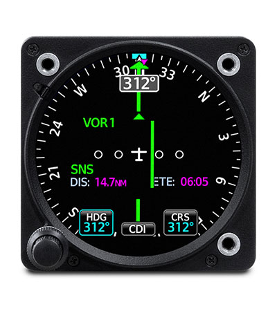
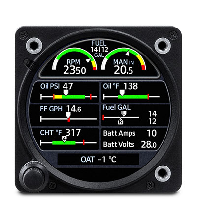
GI 275: Aircraft Flight Instrumentation Reimagined
Introducing GI 275, a powerful electronic flight instrument that directly replaces legacy primary flight instruments in the cockpit. The GI 275 is suitable as a direct replacement for a variety of instruments including, an attitude indicator, attitude directional indicator (ADI), course deviation indicator (CDI), horizontal situation indicator (HSI) and engine indication system (EIS). Capable of serving as a 4-in-1 flight instrument, the GI 275 can also be installed as a standby to a number of glass flight displays and is available with a 60-minute back-up battery. Lightweight and compact, it is intentionally designed to take advantage of the common 3.125-inch flight instrument size, reducing installation time and preserving the existing aircraft panel. It’s also compatible with a variety of third-party autopilots and does not require a separate interface adapter, further reducing installation labor. The GI 275 has received FAA approval and is available immediately for installation in over 1,000 single-engine and multi-engine aircraft models.
Several variants of the GI 275 are available to meet the needs of over one thousand business and general aviation aircraft models. Features beyond the traditional display of attitude, airspeed and altitude include the option to display CDI, HSI, and engine information. The GI 275 is also capable of displaying multifunction display-like features, such as traffic, weather, terrain, SafeTaxi airport diagrams, optional Synthetic Vision Technology (SVT) and more.
“As constant innovators within the avionics industry, we’re redefining
the aircraft cockpit with the introduction of the GI 275,” said Carl Wolf, vice
president of aviation sales and marketing. “With the GI 275, pilots can
take an economical and scalable approach to their avionics upgrade, while
saving on the installation labor and cost. If it’s round and in their panel,
pilots can likely replace it with the GI 275 to receive modern flight display
features and benefits in a powerful, yet compact touchscreen flight
instrument.”
Suitable as a replacement to many aging flight instruments and
gyro-based attitude indicators on the market such as the popular KI-256, the GI
275 gives aircraft owners the benefits of a modern and reliable flight
instrument. The GI 275 boasts a standard 3.125-inch form factor and rear-mount
design that minimizes panel modification. Its bright, high-resolution touchscreen
display and wide viewing angle offers superior readability in the cockpit. A
dual concentric knob allows pilots to access a variety of key functions within
the flight instrument, such as adjustments to the baro setting or the airspeed
bug. Highly scalable, aircraft owners can start with a single GI 275 and add up
to a total of six in a single panel, paving the way for incremental upgrades
and an array of individualized panel configurations.
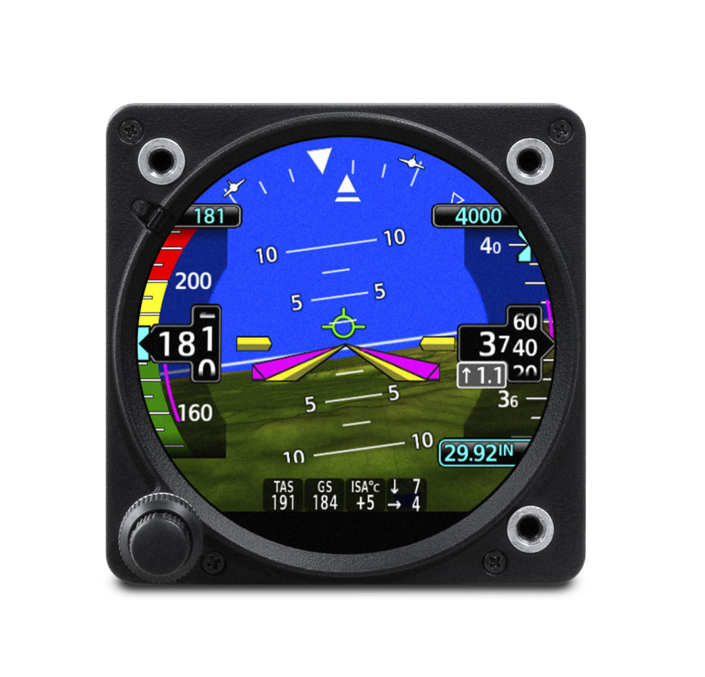
Primary attitude indicator
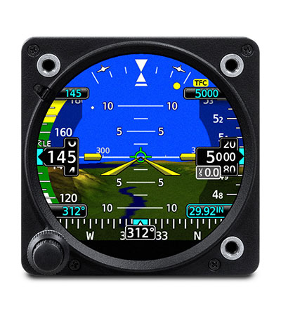
When installed as a primary attitude indicator, the GI 275 offers improved reliability, potential weight savings and reduced maintenance compared to failure-prone vacuum-driven attitude indicators. When the GI 275 serves as primary for attitude information, pilots can also view altitude, airspeed and heading on the instrument. Optional SVT overlays a rich, 3D topographic view of terrain, traffic, obstacles, airport sign posts and more all within the GI 275 attitude display. The GI 275 also overlays a flight path marker within the SVT view, which takes into account crosswind, angle of attack and other factors to show precisely where the aircraft if flying.
The 4-in-1 GI 275 flight instrument is also approved for installation as
a dedicated standby flight instrument to Garmin glass flight displays and is
capable of serving as a back-up to a variety of third-party flight displays on
the market. When installed as a standby to the G500 TXi, the GI 275 is capable
of displaying additional multifunction display features. For back-up navigation
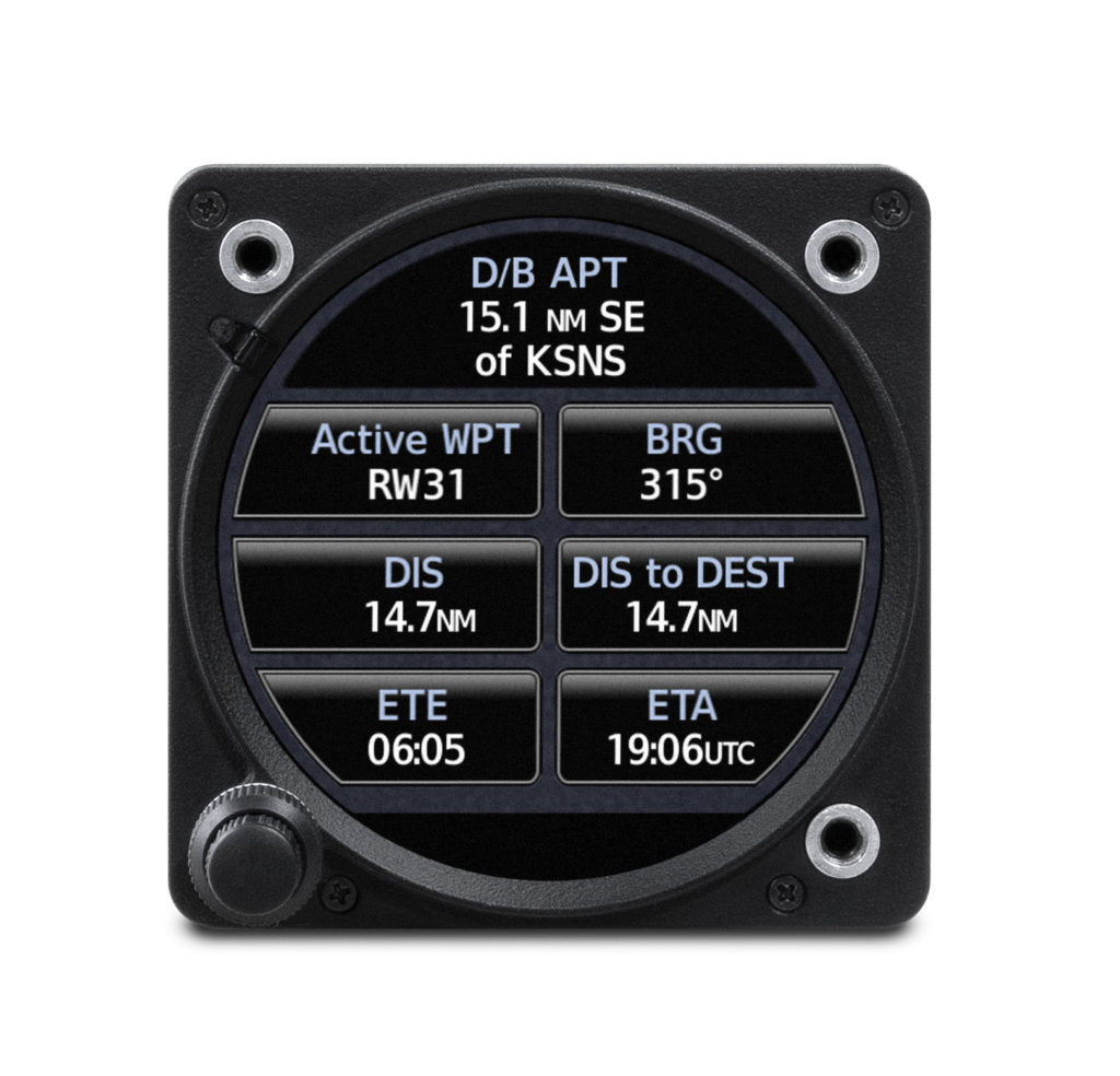
information, a built-in VFR GPS enables convenient direct-to navigation
guidance, displaying aircraft position information on a moving map. In
installations where the GI 275 is installed as a primary or standby flight
instrument, a 60-minute back-up battery is included.
Course Deviation Indicator (CDI) & Horizontal Situation Indicator
(HSI)
When installed as a CDI or HSI, the GI 275 is designed to accept a
variety of GPS or navigation inputs, allowing up to two GPS sources and two VHF
navigation sources. The GI 275 features an Omni Bearing Resolver that allows
the flight instrument to interface to a variety of legacy navigators on the
market without the need for an expensive adapter. With an optional magnetometer,
it is also capable of providing magnetic-based HSI guidance. Vertical and
lateral GPS, VOR/LOC and glide slope deviation can be viewed on the GI 275. CDI
source selection can be accomplished through the touchscreen interface, while
course and heading selection is completed using either the touchscreen or dual
concentric knob. When pilots replace an older mechanical CDI or HSI, the GI 275
doubles as a modern digital indicator and adds MFD-like capabilities such as a
moving map, weather, traffic and terrain.
Suitable as a replacement to display primary engine information
When configured as primary to display engine information, the GI 275 is capable of interfacing with single-engine and multi-engine normally aspirated or turbocharged aircraft with select powerplants, including Lycoming and Continental 4/6-cylinder engines. When the GI 275 replaces mechanical gauges and is configured as primary for engine information, the GI 275 can display RPM, manifold pressure, oil pressure and temperature, cylinder head temperature (CHT), exhaust gas temperature (EGT), turbine inlet temperature (TIT), fuel flow, fuel quantity, fuel pressure, volts and amps. Lean assist functionality is also available so pilots can choose to operate rich of peak or lean of peak. The GI 275 also features exceedance alerting, allowing installers to configure caution and warning alerts per the Pilots Operating Handbook (POH). Advisory alerts such as “high oil temp” or “high CHT” can be configured by the pilot. These exceedances, as well as additional engine data can be shared wirelessly with the Garmin Pilot app on Apple mobile devices and can also be viewed on the flyGarmin website for post-flight analysis. In multi-engine aircraft, dual GI 275’s are required to display engine information.
Multifunction Display
Depending on the configuration and installation, the GI 275 is capable
of displaying additional page functions and features beyond a traditional
flight instrument. These features can include:
- A multifunction display (MFD) with a moving map can display terrain, obstacles, traffic, weather, airspace information, airways, and more.
- When interfaced to a GTX
 345 or GNX 375, traffic information can be displayed on the dedicated traffic page or moving map. Patented TargetTrend relative motion technology and pop-up traffic alerts further enhance situational awareness.
 - The GI 275 can also be interfaced to a variety of traffic systems, including select Traffic Advisory (TAS) and Traffic Alert and Collision Avoidance Systems (TCAS). Traffic advisories are displayed on the dedicated traffic page and moving map.
- SafeTaxi airport diagrams display runways, taxiways, Fixed Based Operators (FBO’s), hangars and more relative to the aircraft’s location on the airport surface.
- Terrain shading incorporates yellow and red contouring depicting the aircraft is 1,000 and 100 feet above ground level (AGL) respectively. Terrain information, as well as obstacle and WireAware database information can be viewed on the terrain and map pages.
- The GI 275 uses its internal terrain and obstacle database to provide audible and visual terrain proximity alerts, including, “terrain ahead, pull up” and “obstacle ahead, pull up.”
- When paired with the GDL 69 datalink receiver, the GI 275 is capable of displaying SiriusXM Aviation Weather. It can also display Flight Information Service-Broadcast (FIS-B) weather from either a GTX 345 or GNX 375.
- An airport information page displays a variety of information, including frequencies, runway dimensions and more.
- The GI 275 can be paired with the GRA 55/5500 and other third-party products to display a radar altimeter on a dedicated page. Visual and aural annunciations are also available.
- The GI 275 is compatible with the GFC 600 autopilot, as well as an array of third-party autopilots and can replace the primary attitude indicator installed with these autopilots. GFC 500 compatibility is expected later this year.
Built-in Wi-Fi enables Database Concierge, the wireless transfer of aviation databases to the GI 275. Pilots also have the option of transferring databases to the GI 275 using a USB flash drive and the GSB 15 USB charger. Databases can also be synced among multiple GI 275 flight instruments in a single cockpit. When configured to display engine information, the GI 275 can wirelessly send engine data to display within the Garmin Pilot app on Apple mobile devices. This data is also automatically synced and can also be viewed on the flyGarmin website. Wireless flight plan transfer via Bluetooth is available when the GI 275 is paired with a GPS 175, GNC 355 or GNX 375. Additional wireless functions include the sharing of GPS position and back-up attitude information with Garmin Pilot.
The GI 275 is available immediately and is approved for installation in over 1,000 single-engine and multi-engine aircraft models. Select Class IV aircraft are also approved, visit www.garmin.com/GI275 for additional information. Customers can purchase the GI 275 through the Garmin Authorized Dealer network and pricing for various configurations of the GI 275 can be found on the website. A trial period of SVT also comes with the purchase of a GI 275 when it’s configured as an attitude indicator. The GI 275 also comes with a two-year warranty and is supported by our award-winning aviation support team, which provides 24/7 worldwide technical and warranty support. Garmin was awarded top honors last year in avionics product support for the 16th straight year by Aviation International News, and earned the top spot in the annual avionics product support survey conducted by Professional Pilot magazinethis year, also for the 16th consecutive year. For additional information, visit www.garmin.com/aviation.
The post GI 275: Aircraft Flight Instrumentation Reimagined appeared first on Garmin Blog.
https://www.garmin.com/en-US/blog/aviation/gi-275-aircraft-flight-instrumentation-reimagined/